
- 157
- 882 221
Engineering Sound
United Arab Emirates
Приєднався 3 жов 2019
Murad Farooq is a professional civil engineer .
"You can look at practically any part of anything man made around you and think, Some engineer was frustrated while designing this. It's a little human connection." My goal for Practical Engineering is to increase exposure and interest in the field of engineering. I'm trying to highlight that connection between the world around us and the energy, passion, and thought that goes into making it a nicer place to live.
"You can look at practically any part of anything man made around you and think, Some engineer was frustrated while designing this. It's a little human connection." My goal for Practical Engineering is to increase exposure and interest in the field of engineering. I'm trying to highlight that connection between the world around us and the energy, passion, and thought that goes into making it a nicer place to live.
Comprehensive Guide to Multiple Road Cross Sections
#RoadCrossSection #RoadDesign #civil3d
Complete Course Roads and Highways Design Course Autodesk Civil 3D Link:
www.udemy.com/course/autocad-civil-3d-complete-course-roads-highways-design/?referralCode=E98F878888FBE57612A1
his guide delves into the intricate world of road cross section designs, providing a thorough exploration of various configurations used in urban, suburban, and rural settings. It aims to equip engineers, urban planners, and infrastructure developers with the knowledge necessary to design roads that are safe, efficient, and sustainable. From the basics of road cross section components to advanced design considerations, this guide covers it all. Topics include lane width, shoulder design, median placement, and drainage solutions, as well as considerations for pedestrian and cyclist infrastructure. Through detailed illustrations, case studies, and best practices, this guide serves as an essential resource for those involved in the planning and development of roadways.
Detailed Topographic and Boundary Survey Course Link.
www.udemy.com/course/autocad-civil-3d-topographic-and-boundary-survey/?referralCode=E30B6399CA0FCCD8C868
6 Kilometers Practically Complete Roads and highways & Junction Design Course Autodesk Civil 3D.
Link:-👇🏻
www.udemy.com/course/autocad-civil-3d-6km-complete-road-junction-desgin-project/?referralCode=731BD041ABF18A16C3D9
* Complete Roads and Highways Design Course Autodesk Civil 3D.
Link:-👇🏻
www.udemy.com/course/autocad-civil-3d-complete-course-roads-highways-design/?referralCode=E98F878888FBE57612A1
* Complete Road design + open channel + Roundabout Design 3 in 1 with very details
Udemy Course link:-
www.udemy.com/course/road-design-with-autocad-civil-3d-open-channel-design/?referralCode=BCBCBE5222CB64526413
AutoCAD civil 3D Topographical and Boundary Survey Course
www.udemy.com/course/autocad-civil-3d-topographic-and-boundary-survey/?referralCode=E30B6399CA0FCCD8C868
For Civil Engineering PDF Books Join Telegram :-
t.me/EngineeringSound
👉Subscribe for more such content.
Money-back guarantee
If you are not satisfied with the course, request a refund within 30 calendar days of your purchase and I will honor the request. That’s how confident I am about my courses. You will be blown away by the training. You can try the course risk-free to understand if it is the type of training you’re looking for, and if not, get 100% of your money back.
Переглядів: 289
Відео
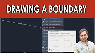

Drawing a Boundary in Autodesk Civil 3D
Переглядів 2273 місяці тому
Drawing a Boundary #autodesk #draw #roaddesign #autocadcivil3d Detailed Topographic and Boundary Survey Course Link. www.udemy.com/course/autocad-civil-3d-topographic-and-boundary-survey/?referralCode=E30B6399CA0FCCD8C868 6 Kilometers Practically Complete Roads and highways & Junction Design Course Autodesk Civil 3D. Link:-👇🏻 www.udemy.com/course/autocad-civil-3d-6km-complete-road-junction-desg...

Dimension Override in AutoCAD and Civil 3D
Переглядів 5498 місяців тому
Are you tired of struggling with dimension overrides in AutoCAD and Civil 3D? Look no further! In this comprehensive tutorial, we'll walk you through the process of utilizing dimension overrides to modify and customize dimensions according to your design needs. Whether you're working on architectural or engineering projects, learning how to effectively use dimension overrides will save you time...

Creating a Superimposed Profile Autodesk Civil 3D
Переглядів 1,9 тис.8 місяців тому
Mastering Superimposed Profiles in AutoCAD Civil 3D: Taking Your Designs to New Heights! Are you ready to take your AutoCAD skills to new heights with Civil 3D? In this course, we'll explore the world of creating superimposed profiles, helping you design and visualize roads, bridges, and other infrastructure projects with precision and flair. Learn how to seamlessly combine multiple profiles, m...

How to Convert Local Coordinate Drawings to UTM and KML, KMZ AutoCAD, and Civil 3D
Переглядів 4,1 тис.10 місяців тому
In this informative video, we explore the process of converting local coordinate drawings to UTM and creating KML/KMZ files in AutoCAD and Civil 3D. Learn essential steps and techniques to ensure accurate data transformation. Join us for a comprehensive guide! 🔨😉 #globalmapper #KMLKMZExport #KMLKMZExport #autocadtips Detailed Topographic and Boundary Survey Course Link. www.udemy.com/course/aut...

How to Adding definition to The Tin Surface AutoDesk Civil 3D
Переглядів 88510 місяців тому
In this comprehensive tutorial, we'll guide you through the process of adding precise definition to a tin surface in AutoDesk Civil 3D. 🔍📐 Discover how to accurately represent surface details, contours, and elevations for better design visualization and analysis. Follow step-by-step instructions, learn expert tips, and watch demonstrations that will help you master this aspect of Civil 3D. Star...

Autodesk Civil 3D Topographic and Boundary Survey Course
Переглядів 1,5 тис.10 місяців тому
"Unlock Your Surveying Potential: Autodesk Civil 3D - Topographic and Boundary Survey Course" Ready to take your surveying skills to the next level? Join us for an exhilarating course on utilizing Autodesk Civil 3D for topographic and boundary surveys. 🗺️📏 In this comprehensive training, we'll guide you through essential techniques, tools, and workflows to accurately capture terrain features an...

Editing Alignment and Alignment Geometry Editor AutoDesk Civil 3D
Переглядів 2,2 тис.11 місяців тому
I'll discuss about in this video How to Editing Alignment and Alignment Geometry Editor AutoDesk Civil 3D #civil3d #alignment #highway complete Data and Drawings set or you want online zoom training or any Work realted Road and highwyas Desgin Contact me :- WhatsApp: wa.me/ 923442542510 Udemy Courses: * 6 Kilometres Practically Complete Roads and highways & Junction Design Course Autodesk Civil...

How to Draw Multiple Cross Section Civil 3D Tutorial
Переглядів 11 тис.Рік тому
📐✍️ "Mastering Multiple Cross-Section Drawing in Civil 3D: Step-by-Step Tutorial" 🚧🖥️ In this comprehensive tutorial, we'll guide you through the process of drawing multiple cross-sections in Autodesk Civil 3D. Learn how to create accurate representations of various terrain profiles, analyze data along a corridor, and efficiently present valuable information. With step-by-step instructions and ...
Alignment Settings Alignment Label & Alignment Reports Autodesk Civil 3D
Переглядів 2,7 тис.Рік тому
🛣️📊 "Harnessing Alignment Settings: Alignment Labels & Reports in Autodesk Civil 3D" 🚀🖥️ Join us in this insightful tutorial as we unlock the power of Alignment Settings, Labels, and Reports in Autodesk Civil 3D. 📏✨ Explore how to effectively display alignment labels and annotate your designs with crucial information. We'll delve further into generating comprehensive alignment reports to analyz...
How to Use Trim and Extend Command in AutoCAD or in Civil 3D.
Переглядів 1,3 тис.Рік тому
How to Use Trim and Extend Command in AutoCAD or in Civil 3D.
How to use Rectangular Array Command in AutoCAD & AutoDesk Civil 3D
Переглядів 690Рік тому
How to use Rectangular Array Command in AutoCAD & AutoDesk Civil 3D
How to Change Curve Radius Autodesk Civil 3d.
Переглядів 2,9 тис.Рік тому
How to Change Curve Radius Autodesk Civil 3d.
Complete AutoCAD Course From Basic Level To Advance Level
Переглядів 607Рік тому
Complete AutoCAD Course From Basic Level To Advance Level
Road Edges Alignment Profile Show on Profile view AutoCAD Civil 3D.
Переглядів 2,6 тис.Рік тому
Road Edges Alignment Profile Show on Profile view AutoCAD Civil 3D.
Complete AutoCAD Course in One Video |Floor Plan| |Elevation| |Section| |3D Modeling| |Rendering|
Переглядів 5 тис.2 роки тому
Complete AutoCAD Course in One Video |Floor Plan| |Elevation| |Section| |3D Modeling| |Rendering|
Making 3D Model and Rendering from Floor Plan AutoCAD: Part 4 of 4
Переглядів 3,3 тис.2 роки тому
Making 3D Model and Rendering from Floor Plan AutoCAD: Part 4 of 4
Making a Section View from floor Plan: Part 3 of 4
Переглядів 2,4 тис.2 роки тому
Making a Section View from floor Plan: Part 3 of 4
Making Complete Elevation View From Floor Plan: Part 2 of 4
Переглядів 3,4 тис.2 роки тому
Making Complete Elevation View From Floor Plan: Part 2 of 4
Making a Complete Floor Plan in AutoCAD: Part 1 of 4
Переглядів 17 тис.2 роки тому
Making a Complete Floor Plan in AutoCAD: Part 1 of 4
How to Create Blocks Legends Table in AutoCAD & AutoCAD Civil 3d with the help of Auto Lisp.
Переглядів 11 тис.2 роки тому
How to Create Blocks Legends Table in AutoCAD & AutoCAD Civil 3d with the help of Auto Lisp.
How to Change Line & Polyline Thickness and lineWeight In AutoCAD |AutoCAD Civil 3D|.
Переглядів 7 тис.2 роки тому
How to Change Line & Polyline Thickness and lineWeight In AutoCAD |AutoCAD Civil 3D|.
How display Easting, Northing and Elevation on any object or point without Lisp in AutoCAD & 3D
Переглядів 11 тис.2 роки тому
How display Easting, Northing and Elevation on any object or point without Lisp in AutoCAD & 3D
AutoCAD Quick Multi Area Calculation Auto Lisp with one Click |Area Calculation| Autodesk.
Переглядів 21 тис.2 роки тому
AutoCAD Quick Multi Area Calculation Auto Lisp with one Click |Area Calculation| Autodesk.
How to Draw Alignment from Object |Draw Polyline| Arc Polyline |Polyline Width | Polyline Radius.
Переглядів 1,7 тис.2 роки тому
How to Draw Alignment from Object |Draw Polyline| Arc Polyline |Polyline Width | Polyline Radius.
Complete Road design, Open Channel & Roundabout Design Course Zero to Hero all Level and beginners
Переглядів 1,7 тис.2 роки тому
Complete Road design, Open Channel & Roundabout Design Course Zero to Hero all Level and beginners
How to Design YouTube Logo in AutoCAD Civil 3D |Autodesk|
Переглядів 4342 роки тому
How to Design UA-cam Logo in AutoCAD Civil 3D |Autodesk|
3 Most important text commands for AutoCAD and AutoCAD Civil 3D.
Переглядів 4292 роки тому
3 Most important text commands for AutoCAD and AutoCAD Civil 3D.
AutoCAD Lisp for Quick measurement and dimensions
Переглядів 6 тис.2 роки тому
AutoCAD Lisp for Quick measurement and dimensions
AutoCAD Lisp for measurement of different object by one Click Laylenght LISP AutoCAD civil 3d,
Переглядів 1,6 тис.2 роки тому
AutoCAD Lisp for measurement of different object by one Click Laylenght LISP AutoCAD civil 3d,
Hi good job.👍 I have a 3d module house wall made of wood. how can I make the table automatically so that the name and width, thickness, and length of each element are displayed. Do you have any ideas?
Dear Brother how we can be assure that this alignment is 100% good which one we draw. maybe we can give less degree of curve to this alignment
You need to follow the requirements and standards spec
@@EngineeringSounds this is not a ethnic answer
thank u sir..
Welcome
Does it affect objects in the drawings like roads and pipes,etc ?
Thanks for your valuable videos 🌹
Sir 43Q ka Zone kya hoga
I want to know if I can change settings of text for any lisp thanks
lot of thanks
Super
where do you get text files from Point Creation Tools
Revit me kese hoga sir
Important video helpful for Google maps....❤
❤🎉❤
Nice explanation
Thanks for sharing your Lisp Routine, that is very helpful, thanks again
Wat if I need volume done halfway da road
Asslamoelkum sir can you make tutorial on global mapper
hi have a question...in corridor surface (boundaries tab) when I RC on item, add automatically, "Daylight and Hinge" dosnt appears in menu to select whats its problem? tnx
Good......
Thank you
Hello,can you share the survey data used in this video please
Thank you!!!
If the distances are not same...........?
Can you find the Reduce Level (Z) for the coordinates aswell?
جزاكم الله خيرا ❤❤✌✌
Welcome back❤❤
Is that working in Cut-off Trench?
Thank sir , how do I create my own band I see in the video that you used your template
Check my others videos I already uploaded
Thanks sir assist us with datasets
Thank you so much for a helpful and practical video!!! 😊😊
Is this information included in your Udemy courses?
Yes even more than that links in the descriptions
Eagle point
Eagle point
Eagle point ka time kab ka khtam h ab
But eagle point crossection K point of view say professional ha just typical crossection
Eagle point
Eagle point road calc...
Eagle point road calc per video bnao
Every chainage calculate and show
Every chainage show earth work
Thanks. Question: Is there any way that the size in the textfield changes when making changes to the size of the object?
the link is not existing
Véry good freind
This is exactly whaty I need, however, I receive the following error message, error: bad argument type: (or stringp symbolp): nil. Any ideas wouild be greatly appreciated. Thanks.
Thank you it works very good
When i save as kml there is no kml to dwg file how can i solve that
great video ...free of cost available here but paid on udemy
Great video, cheers.
Very very nice.
Hi Farooq. Thanks for creating this tutorial. One doubt I have here is, if this is a water channel, is it possible to give negetive slope in profile? water will not flow against gravity.
Me central Africa mai hu or idharka zone hi nahi show karta idharka zone hai 35 L hai
This work on crack version also
Yeah